


Mount Everest is more than just the tallest mountain in the world. It is a living piece of our planet's history. It was shaped slowly over tens of millions of years. When we look at its huge height and sharp ridges today, it is easy to think that it has always been this way. But Everest was not born overnight, so how was Mount Everest formed? It rose step by step, layer by layer, through powerful natural forces deep inside the Earth.
Knowing how Mount Everest was formed will help you understand how our planet works. The Earth's surface is not fixed; it moves like a giant puzzle made of plates. These plates float on the hot, safe layer below the crust, constantly shifting, pushing, and colliding. When two giant plates meet, incredible things happen: mountain rises, rocks change, oceans disappear, and new landscapes are created.
Everest's story is exactly a slow-motion collision of enormous landmasses that lifted rocks from the bottom of an ancient ocean to more than 8,000 meters above sea level. Scientists have studied Everest's rocks, measured its height, and traced its timeline to reveal a clear story. Everest is a result of one of the biggest geological events on Earth.
Today, when climbers stand on the summit, they are actually standing on rock that was once underwater; it is part of a prehistoric sea filled with shells and sand. This transformation from sea underwater to sky as the highest peak makes Everest one of the greatest natural wonders.
Today, we will explore how all this happened, step by step, and observe the scientific evidence that explains how Everest came to stand where it is today.
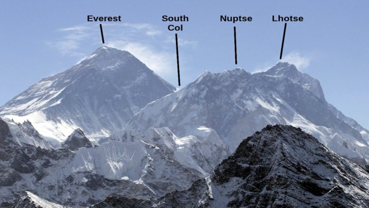
How Was Mount Everest Formed?- The Birth of the Himalayas
Millions of years ago, the world seemed very different from today. The land that is now India was not attached to Asia. Instead, it was a huge island continent drifting slowly northward across the ocean. This piece of land is called the Indian Plate. This plate moved at a surprising speed for a tectonic plate, around 15-20 centimeters per year. It moves almost as fast as your fingernails grow, but on a giant scale.
On the other side was the Eurasian plate, which holds modern-day Asia. For millions of years, these two massive plates drifted closer, pushed by the powerful forces beneath Earth's crust. Around 50-60 million years ago, the Indian Plate finally crashed into the Eurasian Plate. This collision was not a sudden impact like a car crash over millions of years. But the force behind the crash was enormous, which was strong enough to change the face of the planet.
When the two plates met, neither one could slide under the other because both were made of light, continental crust. Instead, the land between them began to crumple, fold, a nd rise upward. Imagine pushing two sheets of paper together; the middle part wrinkles and rises. This is exactly what happened on a massive scale. As the crust pushed upward, it created a long chain of mountains that would become the Himalayas.
This process is known as continental collision, which is one of the most powerful geological forces on Earth. The incredible pressure caused rocks from deep underground to rise, forming towering peaks. Among these peaks, one of the mountains grew higher than all the rest of which we call Mount Everest.
The collision between the Indian and Eurasian plates is still happening even today. This is why the Himalayas continue to rise and why the region experiences frequent earthquakes. Everest's entire existence began with this slow but unstoppable push of continents. There is a force that continues shaping the landscape millions of years later.
The Story of the Tethys Sea
Before Mount Everest ever existed, the place where it stands today was once the floor of a warm, shallow ocean, which is called the Tethys Sea. This ancient sea stretched between the drifting Indiana continent and the huge Eurasian landmass. For millions of years, rivers carried sand, mud, tiny shells, and the remains of sea creatures into this ocean. These materials slowly settled on the seabed, forming thick layers of sediment.
Over time, these sediments hardened into different types of rocks. They are especially turned in limestone, which forms when layers of shells and marine organisms get compressed. This detail is essential because it helps scientists to prove that Everest was once underwater. Fossils of ancient ocean creatures, including small shelled organisms, have been found at an altitude above 8,000 meters. These fossils serve as natural evidence that the rock at the top of the world once lay at the bottom of a sea.
When the Indian and Eurasian plates collide, the seabed between them does not disappear. Instead, the huge pressure began pushing the seabed upward. The layers of limestone, sandstone, and shale that were once resting quietly under water started rising, folding, and stacking on top of each other. This uplift eventually formed the highest peaks of the Himalayas.
The Tethys Sea slowly disappeared as the land rose, but the rocks left behind tell the full story. Today, when climbers reach the summit of Everest, they stand on ancient ocean floor material that has travelled nearly 9 kilometers upward over millions of years.
The Geological Materials That Built Everest
Mount Everest may look like a single solid pyramid of rock, but in reality, it is made up of different layers. These layers formed at other times in Earth's history. Each layer tells a story about where it came from, how it was formed, and what the world looked like millions of years ago. By studying these layers, scientists can trace Everest's journey from sea seafloor to sky sky-high peak.
The summit of Mount Everest is made mostly of limestone. Limestone is a rock created from compressed shells and marine organisms. This is the same type of rock usually found near warm, shallow oceans. The presence of limestone at the highest point on the Earth is one of the strongest proofs that Everest was once underwater in the Tethys Sea. Just below the summit, the rocks change to shale and sandstone, which were formed from mud and sand deposited over long periods. These softer rocks show the different environments that existed in ancient oceans with more sand, mud, and changing water conditions.
Near the base of Everest, the rocks look very different. Here you can find metamorphic rocks such as Genesis and schist. These rocks were once ordinary sedimentary rocks, but over millions of years, they were buried deep underground, heated and squeezed by massive pressure. This intense process changed their structure and turned them into harder and more compact rocks. These metamorphic layers represent some of the oldest parts of Everest's foundation.
Geologists use these rock types like pages of a natural history book. By analyzing the minerals, fossils and the arrangements of layers, they can understand how the mountain rises, how much force was involved, and how the environment changed through time. Each layer adds a new chapter to Everest's kind and dramatic geological story.
Uplift That Continues Everest is Still Growing
Mount Everest may look ancient and unchanging, but it is actually a living and rising mountain. The process that created it millions of years ago has not stopped. In fact, the Indian plate is still slowly pushing into the Eurasian Plate due to this continued pressure that keeps lifting the Himalayas upward. Scientists call this process tectonic uplift, which is the main reason Everest continues to grow taller every year.
According to modern geological measurements, Everest rises by about 4-5 millimeters per year. While this seems small, it becomes significant over long periods. Over a century, the mountain can grow nearly half a meter. One of the reasons we know this with confidence is because of high-precision GPS technology. Survey teams from Nepal and China have placed GPS instruments on and around Everest to track even the tiniest movements of the Earth's crust. These devices provide clear data that confirms the ongoing uplift.
In 2020, Nepal and China jointly measured Everest's height using updated GPS and radar technology. They announced a new official height of 8,848.86 meters, which is slightly higher than earlier measurements. This rise is partly due to natural uplift from tectonic pressure and partly from changes caused by earthquakes.
However, uplift is not the only factor affecting Everest's height. Weathering, melting glaciers, and erosion slowly wear down the mountain from the outside. So, while tectonic forces push Everest upward, natural erosion tries to bring it down. The result is a continuous balancing act where one force lifts, another force shapes, and carvings.
This dynamic process shows that Everest is far from a silent, motionless giant. Instead, it is an active geological structure that is still changing in response to powerful forces within the Earth. Every year, even if only by a few millimeters, the world's highest peak continues its climb towards the sky.
Ice, Snow, and Erosion at Work Shaping the Mountain
Even though tectonic forces built Mount Everest, its sharp ridges, deep valleys, and iconic pyramid shape were carved mainly by ice, snow, wind, and time. These natural forces constantly reshape the mountain. They slowly wear it down while also giving it the drama that we see today.
Everest is covered by some of the world's largest and highest glaciers. It includes the Khumbu Glacier, Western Cwm Glacier, and Kangshung Glacier. Glaciers are like slow-moving rivers of ice that grind and scrape the rock beneath them. These glaciers creep downhill under their own weight, carving out deep valleys, smooth mountain surfaces, and transporting huge amounts of rock and debris. This process is called glacial erosion, which is one of the most powerful sculpting forces on Everest.
Another important process is freeze-thaw weathering. At Everest's altitude, temperatures can drop below freezing even in the daytime. Water seeps into cracks in the rock, freezes at night, and expands. This expansion widens the crack, which eventually breaks the rock part. Over millions of years, the simple cycle has shaped cliffs, ridges, and rock faces all across the mountain.
Wind also plays a major role. The jet stream with winds that can exceed 150km/h blasts the summit throughout the year. These strong winds blow loose snow and ice off the peak while exposing bare rock, sharpening the mountain's features.
In recent decades, another factor has begun shaping the Everest is climate change. Studies show that many glaciers around Everest are shrinking faster than before, which changes the landscape over time. As the ice melts, the valley may widen and rockfalls may increase.
All these forces, such ice, wind, snow, and temperature, work together to sculpt Everest continuously. Even though mountains raise these erosion processes constantly carve it into breathtaking form, admired around the world.
You may also like:
- Where is Mount Everest Located?
- Hire Guide and Porter in Nepal
- Can You Summit Everest Without Supplemental Oxygen?
- Everest Base Camp Trek
Everest Rough Journey: Earthquakes and Mountain Building
Mount Everest stands where two restless tectonic plates meet; it means that the mountain is constantly affected by the powerful forces beneath Earth's crust. One of the clearest signs of this ongoing activity is the frequent earthquakes in the Himalayan region. These earthquakes are not random; they are a direct result of the Indian Plate continuing to push into the Eurasian Plate.
The Indian plate still moves about 4-5 centimeters per year, which is one of the fastest movements of any continental plate on Earth. As it pushes northward, the pressure along the plate boundary builds up. When this pressure becomes too great, it releases suddenly in the form of earthquakes. These quakes can be small and harmless or sometimes large and destructive, like the 2015 Nepal earthquake, which measured 7.8 magnitude. That earthquake shifted the land by several meters, which altered the height of some Himalayan peaks and affected the region's geological structure.
Earthquakes also play a role in shaping mountains. During major quakes, some sections of rock are lifted, folded, or moved. Sideways movements are usually small, often just a few millimeters or centimeters. They show that the landscape is constantly adjusting. In some cases, earthquakes can even cause minor changes in Everest's height. After the 2015 earthquake, scientists noticed slight vertical and horizontal shifts in the mountain's position. They confirm that Everest is not fixed in one spot.
Earthquakes also contribute to rockfalls, avalanches, and landslides, which further sculpt the mountain's surface. When earthquake energy shakes loose rocks and ice. It accelerates erosion and reshapes slopes and valleys. Everest's journey has always been rough. It is shaped by collisions, lifted by tectonics, and shaken by powerful quakes that continue to influence its form even today.
The Modern Everest: A Living Mountain
Mount Everest may be millions of years old, but it is far from finished. Today, Mount Everest stands at an impressive 8,848.86 metres, but these numbers are not permanent. Everest continues to change each year slowly because the same geological forces that created it are still active beneath the Earth's crust. The Indian plate keeps pushing towards Asia, land is reshaped by glaciers and climate patterns shift. This constant activity makes Everest a living natural structure, always moving and always adjusting.
Modern science has helped us to understand these changes with greater accuracy. Advanced tools like space stations, satellite measurements, and radar mapping allow researchers to track tiny movements in the mountain's height and position. These instruments show that Everest rises a few millimeters each year due to tectonic uplift but also loses materials as glaciers melt, winds erode the summit, and rockfalls reshape its slopes. The result is an ongoing balance between rising forces below and weathering forces above.
Climate change is adding a new layer of transformation. Many glaciers around Everest are retreating faster than before, altering the mountain's appearance and affecting the surrounding valleys. As the temperature increases, ice melts earlier in the year, which exposes more rocks and increases the risk of avalanches and landslides. These shifts show that even the world's highest mountain is sensitive to environmental change.
Besides these challenges, Mount Everest remains one of Earth's most remarkable geological monuments. Its rocks hold the memory of ancient oceans, its height reflects millions of years of tectonic movement, and its shape is a product of ice, wind, and time. When climbers reach the summit, they stand on a mountain that continues to rise, shift, and evolve. Mount Everest is a reminder that our planet is always alive and transforming.
