

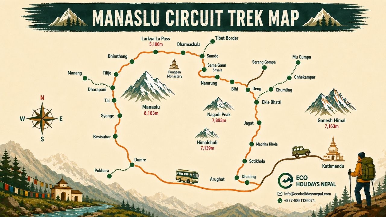
The Manaslu Circuit Trek Map gives you a clear picture of how the journey unfolds around Mount Manaslu, the world’s eighth-highest mountain at 8,163 meters. Unlike simply reading an itinerary day by day, a good route map lets you see the entire trek in context, where the trail begins, how it climbs through mountain villages, where the major elevation gains occur, and how the route crosses the Himalayas before descending into the Marsyangdi Valley.
The trek begins around Machha Khola at approximately 870 meters and follows the Budhi Gandaki Valley through settlements such as Jagat, Deng, Namrung, Lho, Sama Gaun, and Samdo. From Samdo, the trail continues toward Dharamsala before reaching the highest point of the circuit, Larke La Pass at 5,106 meters (16,752 feet). After crossing the pass, the route descends through Bimthang and continues toward Dharapani, where the Manaslu Circuit connects with the Annapurna region.
Our detailed Manaslu Circuit Trek map below shows this entire route along with the major villages, trekking sections, elevations, distances, mountain passes, rivers, and important landmarks. You can use it to understand the geography of the trek at a glance and see how the landscape changes as you move from the lower valleys into the high Himalayan terrain. For anyone planning the trek, the map is also a useful reference for understanding daily walking stages, acclimatization points, and the demanding approach to Larke La.
Manaslu Circuit Trek Map
The Manaslu Circuit Trek Map gives you a visual overview of the complete 14-day journey, from the roadhead at Soti Khola (730 m) to the high point of Larke La Pass (5,106 m) and down through the lower Marsyangdi Valley to Syange. The route first follows the Budhi Gandaki Valley, passing through Machha Khola, Jagat, Philim, Deng, Namrung, Lho Gaon, Samagaon, and Samdo before reaching Dharamshala (Larke Phedi), the final stop before the pass.
From Dharamshala, the trail climbs toward Larke La and then makes a significant descent to Bimthang (3,590 m). The route continues through Tilche and Dharapani before reaching Syange, where the trekking portion ends. In total, this itinerary covers approximately 179.6 km (111.6 miles) of trekking, with additional road journeys between Kathmandu, Soti Khola, and Syange.
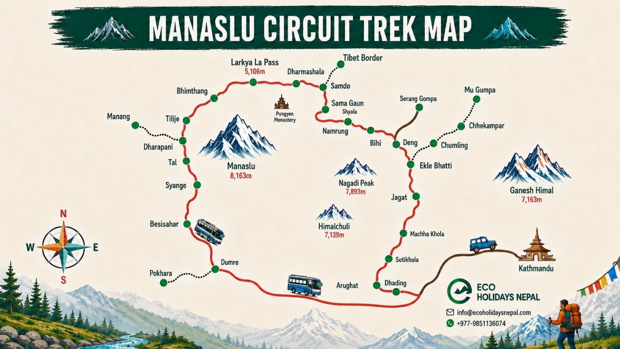
The map also helps put the elevation profile into perspective. The trek begins at 730 meters and gradually climbs through the Budhi Gandaki Valley, reaching 3,530 meters at Samagaon, where an acclimatization day is included. From there, the trail continues to Samdo (3,875 m) and Dharamshala (4,460 m) before reaching the highest point at 5,106 meters. After crossing Larke La, the trail drops sharply toward Bimthang and continues descending through Tilche and Dharapani.
You can use the map alongside the itinerary to understand each day's route, distance, walking time, and elevation change. It is particularly useful for identifying the longer stages, such as Machha Khola to Jagat (22.2 km), Dharamshala to Bimthang via Larke La (24.7 km), and Bimthang to Tilche (26.3 km), while also seeing where shorter stages and the acclimatization day allow for a more gradual adjustment to altitude.
Major Places Shown on the Manaslu Circuit Trek Map
-
Soti Khola: At 730 m (2,395 ft), Soti Khola is the starting point of the trekking section in this 14-day itinerary. The journey reaches here by road from Kathmandu via Arughat, covering approximately 141 km in 6 to 7 hours.
-
Machha Khola: Located at 870 m (2,854 ft), Machha Khola is the first major overnight stop after beginning the trek. The trail from Soti Khola covers 14.1 km and takes around 5 to 6 hours, following the Budhi Gandaki Valley deeper into the Manaslu region.
-
Jagat: At approximately 1,290 m (4,232 ft), Jagat is reached after a 22.2 km trek from Machha Khola. The 6 to 7 hour route continues through increasingly narrow valleys and marks an important transition toward the higher sections of the circuit.
-
Deng: The trail reaches Deng at 1,860 m (6,102 ft) after passing through Philim (1,570 m). This stage covers about 19.9 km and takes 7 to 8 hours, with a steady elevation gain as the route moves farther into the Budhi Gandaki Valley.
-
Namrung: At 2,660 m (8,727 ft), Namrung represents a noticeable step into higher mountain terrain. The route from Deng covers 19.5 km in approximately 5 to 6 hours, gaining around 800 meters in elevation.
-
Lho Gaon: Located at 3,180 m (10,433 ft), Lho Gaon is reached from Namrung after an 11 km walk of around 5 to 6 hours. The surrounding landscape becomes more distinctly alpine, with the mountains appearing much closer as the trail climbs above 3,000 meters.
-
Samagaon: At 3,530 m (11,581 ft), Samagaon is one of the most important points on the map. The trail from Lho covers 9 km and takes about 5 to 6 hours. An additional acclimatization day is scheduled here before continuing toward Samdo and the higher sections of the route.
-
Samdo: Sitting at 3,875 m (12,713 ft), Samdo is reached after a relatively short 8.2 km walk from Samagaon, taking around 3 to 4 hours. Its position makes it an important stop before the route climbs beyond 4,000 meters.
-
Dharamshala / Larke Phedi: At 4,460 m (14,632 ft), Dharamshala is the last overnight stop before crossing Larke La Pass. The stage from Samdo is only 6.6 km, but the 585-meter elevation gain makes it an important preparation day for the pass crossing.
-
Larke La Pass: The highest point of the trek stands at 5,106 m (16,751 ft). The route crosses the pass from Dharamshala before descending toward Bimthang. This is also the longest and one of the most demanding stages, covering 24.7 km in approximately 7 to 8 hours.
-
Bimthang: At 3,590 m (11,778 ft), Bimthang comes after the major Larke La crossing. The descent from the pass brings a substantial change in elevation and scenery, marking the transition from the high alpine section toward the lower Marsyangdi Valley.
-
Tilche: Located at 2,262 m (7,421 ft), Tilche is reached from Bimthang after a long 26.3 km trekking stage of around 7 to 8 hours. The route loses approximately 1,328 meters of elevation, making this one of the biggest downhill sections of the itinerary.
-
Dharapani: At 1,860 m (6,102 ft), Dharapani lies farther down the Marsyangdi Valley and connects the Manaslu route with the wider Annapurna trekking network. In this itinerary, the trail continues through Dharapani toward Syange rather than ending here.
-
Syange: Syange marks the end of the trekking section in this itinerary. From Tilche, the route passes through Dharapani and Jagat before reaching Syange, covering 17.9 km in approximately 6 to 7 hours. The following day, a 175 km drive of around 7 to 8 hours brings you back to Kathmandu.
Manaslu Circuit Trek Route Map
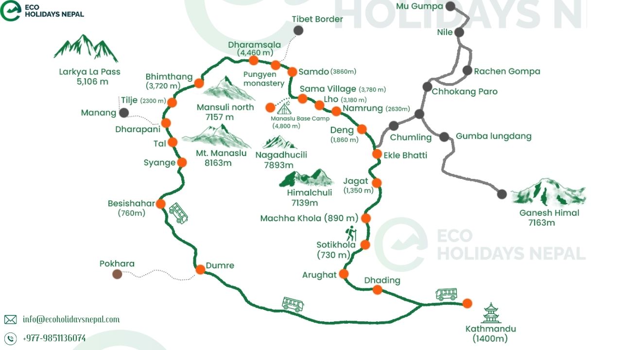
The Manaslu Circuit Trek route map follows a clear progression from the lower hills of central Nepal into the high Himalayan landscape surrounding Mount Manaslu. The journey begins with a road drive from Kathmandu toward Soti Khola, followed by a gradual climb along the Budhi Gandaki Valley. As the trail moves north, the settlements become smaller, the valleys narrower, and the elevation steadily increases. The route reaches its highest point at Larke La Pass (5,106 m) before dropping dramatically toward Bimthang and eventually joining the Marsyangdi Valley around Dharapani. The route below follows the same sequence as the 14-day itinerary, giving you a better understanding of how each section fits into the complete circuit.
Kathmandu to Machha Khola
The journey begins in Kathmandu at 1,400 m, but the actual trekking section starts farther northwest at Soti Khola (730 m). The drive covers approximately 141 km and takes around 6 to 7 hours, passing through Arughat before reaching Soti Khola. Depending on road conditions, this is a long but important transition from the Kathmandu Valley into the foothills of the Manaslu region. From Soti Khola, the trail follows the Budhi Gandaki Valley toward Machha Khola (870 m). This first walking stage covers 14.1 km and takes approximately 5 to 6 hours. Machha Khola therefore serves as the first major trekking settlement on the route, with the trail continuing deeper into the valley from here.
Machha Khola to Jagat
The route from Machha Khola to Jagat covers around 22.2 km and takes approximately 6 to 7 hours. Along the way, the trail passes through settlements and landmarks including Khorlabesi, Tatopani, and Dovan before reaching Jagat at approximately 1,290 m. This section continues to follow the Budhi Gandaki River, with the trail moving through steep-sided valleys and crossing suspension bridges along the way. The elevation gain is still moderate at this stage, but the route is becoming progressively more mountainous as it moves farther from the lower valleys.
Jagat to Namrung
From Jagat, the trail continues through Philim before reaching Deng (1,860 m) and eventually Namrung (2,660 m). The itinerary places Deng as the next overnight stop, with the Jagat to Deng section covering 19.9 km in 7 to 8 hours and passing through Philim at around 1,570 m. The following day, the route from Deng to Namrung covers another 19.5 km, taking approximately 5 to 6 hours while gaining around 800 meters. Villages such as Ghap lie along this section of the trail. By the time you reach Namrung, the route has moved well into the higher Manaslu landscape, and the surrounding mountains become increasingly prominent.
Namrung to Sama Gaun
The route continues upward from Namrung through Lihi and Sho before reaching Lho Gaon at 3,180 m. This section covers approximately 11 km and takes 5 to 6 hours. The trail then continues from Lho to Sama Gaun (3,530 m), covering another 9 km in around 5 to 6 hours. This is one of the most significant transitions on the map. The trail moves above 3,000 meters, and the landscape becomes distinctly alpine. Sama Gaun is also strategically important because the itinerary includes a full acclimatization day here before the route continues toward the higher settlements.
Sama Gaun to Samdo and Dharamsala
After acclimatizing at Sama Gaun, the route continues toward Samdo (3,875 m). The distance is relatively short at 8.2 km, taking around 3 to 4 hours, but the elevation continues to increase. From Samdo, the trail climbs farther toward Dharamsala, also known as Larke Phedi, at 4,460 m. This stage covers only 6.6 km and takes approximately 4 to 5 hours, but the 585-meter elevation gain makes it an important preparation stage before the Larke La crossing. On the map, this is where the route leaves the more settled upper valley and enters the high-altitude section leading directly toward the pass.
Dharamsala to Larke La and Bimthang
The most dramatic section of the Manaslu Circuit begins at Dharamsala. From here, the trail climbs toward Larke La Pass at 5,106 m (16,751 ft), the highest point on the entire route. After crossing the pass, the trail makes a long descent toward Bimthang at 3,590 m. The complete Dharamsala to Larke La to Bimthang stage covers approximately 24.7 km and takes around 7 to 8 hours, making it one of the longest and most demanding days of the trek. The map makes the scale of this section particularly clear: the route rises above 5,000 meters before dropping more than 1,500 meters to Bimthang. This dramatic change marks the geographical turning point of the circuit, taking trekkers from the high Manaslu terrain toward the Marsyangdi side of the Himalayas.
Bimthang to Dharapani
After spending the night at Bimthang, the trail continues through the lower mountain landscape toward Tilche (2,262 m). The route passes through settlements including Gho before reaching Tilche after a demanding 26.3 km stage that takes around 7 to 8 hours. The elevation drops by approximately 1,328 meters during this section. From Tilche, the route continues toward Dharapani (1,860 m), passing through the Marsyangdi Valley and connecting with the broader Annapurna trekking route. In this 14-day itinerary, the trail does not finish at Dharapani; it continues through Dharapani and Jagat to Syange, covering approximately 17.9 km in another 6 to 7 hours.
From Syange, the trekking portion ends and the journey returns to Kathmandu by road. This final drive covers approximately 175 km and takes around 7 to 8 hours, completing the circuit and bringing the route back to its starting city.
Manaslu Circuit Trek Elevation Map
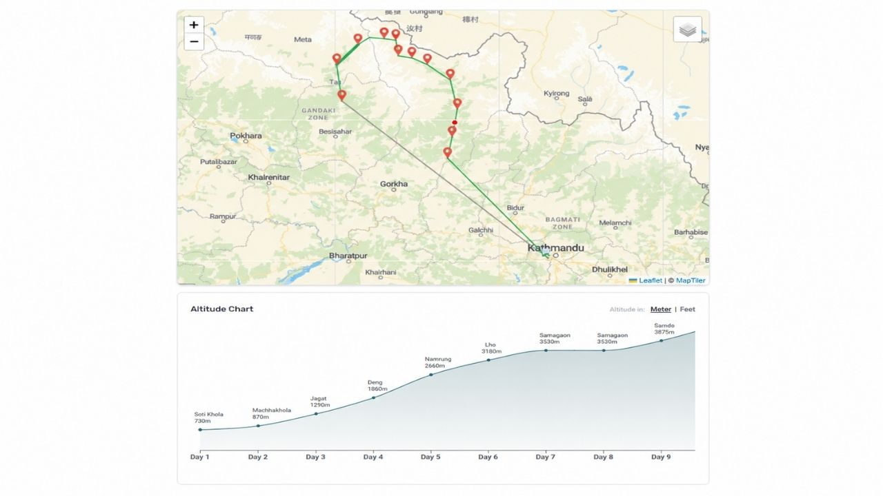
The Manaslu Circuit Trek elevation map shows how the trail climbs from the lower Budhi Gandaki Valley to the high Himalayan pass of Larke La before descending into the Marsyangdi Valley. The elevation changes are gradual during the first half of the trek, giving the body time to adjust as the route moves from Soti Khola at 730 m through Machha Khola, Jagat, Deng, Namrung, and Lho. The biggest altitude gain begins after Namrung, with the trail reaching 3,530 m at Sama Gaun, followed by Samdo at 3,875 m and Dharamshala at 4,460 m.
The highest point comes on the crossing of Larke La Pass at 5,106 m (16,751 ft). From the pass, the route descends sharply to Bimthang at 3,590 m, followed by another substantial drop toward Tilche and Dharapani. This elevation profile is important when planning the trek because the most demanding altitude section is concentrated around Samdo, Dharamshala, and Larke La, while the earlier stages provide a more progressive climb.
Manaslu Circuit Trek Elevation Profile
|
Location |
Elevation Profile |
Elevation Context |
|
Kathmandu |
1,400m / 4,593ft |
Starting city |
|
Soti Khola |
730m / 2,395ft |
Trekking starting point |
|
Machha Khola |
870m / 2,854ft |
Early trekking stage |
|
Jagat |
1,290m / 4,232ft |
Lower Budhi Gandaki Valley |
|
Deng |
1,860m / 6,102ft |
Beginning of sustained elevation gain |
|
Namrung |
2,660m / 8,727ft |
Higher mountain terrain |
|
Lho Gaon |
3,180m / 10,433ft |
Above 3,000 meters |
|
Sama Gaon |
3,530m / 11,581ft |
Acclimatization point |
|
Samdo |
3,875m / 12,713ft |
High-altitude village |
|
Dharamshala / Larke Phedi |
4,460m / 14,632ft |
Final stop before the pass |
|
Larke La Pass |
5,106m / 16,751ft |
Highest point of Manaslu Circuit Trek |
|
Bimthang |
3,590m / 11,778ft |
Major descent after the pass |
|
Tilche |
2,262m / 7,421ft |
Lower Marsyangdi Valley |
|
Dharapani |
1,860m / 6,102ft |
Connection with Annapurna route |
|
Syange |
1,100m / 3,608ft |
End of trekking section |
The elevation profile starts unusually low for a Himalayan trek because the road takes you directly to Soti Khola at 730 meters. From there, the route initially gains altitude in relatively small increments, reaching Machha Khola at 870 meters and Jagat at 1,290 meters. By Deng, the elevation reaches 1,860 meters, and the climb becomes more noticeable as the trail heads toward Namrung at 2,660 meters.
The next stages take the route above 3,000 meters. Lho Gaon at 3,180 meters is followed by Sama Gaun at 3,530 meters, where the itinerary includes a dedicated acclimatization day. This rest day is particularly important because the following stages take you beyond 3,800 meters and eventually above 5,000 meters.
After Sama Gaun, the trail climbs to Samdo at 3,875 meters and then to Dharamshala at 4,460 meters. Although the walking distances on these stages are relatively short: 8.2 km from Sama Gaun to Samdo and 6.6 km from Samdo to Dharamshala, the increasing altitude makes them more demanding than the distance alone suggests.
From Dharamshala, the elevation profile reaches its highest point at Larke La Pass (5,106 m). The trail then descends dramatically to Bimthang at 3,590 meters. The following day continues this downward trend, with the route dropping to Tilche at 2,262 meters before reaching Dharapani at 1,860 meters. This sharp post-pass descent creates one of the most noticeable changes on the elevation map.
Highest Point on the Manaslu Circuit Trek
The highest point of the Manaslu Circuit Trek is Larke La Pass at 5,106 meters (16,751 feet). It is reached after spending the previous night at Dharamshala/Larke Phedi at 4,460 meters. The approach to Larke La is a substantial altitude gain rather than a sudden climb from the lower valleys. By this point, trekkers have already progressed through Machha Khola, Jagat, Deng, Namrung, Lho, Sama Gaun, and Samdo, with Sama Gaun providing a dedicated acclimatization day at 3,530 meters.
The pass-crossing day is also one of the longest stages of the itinerary. The route from Dharamshala over Larke La and down to Bimthang covers approximately 24.7 km and takes around 7 to 8 hours. The combination of high altitude, a 5,106-meter pass, and a long descent makes this the key physical challenge represented on the elevation map.
Manaslu Circuit Trek Elevation Gain and Loss
The trek's elevation profile is not a continuous climb. Instead, it follows a steady ascent toward Larke La followed by a pronounced descent. During the first stages, the trail climbs from Soti Khola at 730 meters to Machha Khola, Jagat, and Deng. The more substantial gains begin around Deng, with the route reaching Namrung at 2,660 meters and then Lho at 3,180 meters. The elevation continues upward to Sama Gaun at 3,530 meters, followed by Samdo at 3,875 meters and Dharamshala at 4,460 meters. This gradual progression is important because it spreads the overall elevation gain across several trekking days instead of reaching high altitude immediately.
The biggest upward point is Larke La at 5,106 meters. After crossing the pass, the profile changes completely: the trail drops to Bimthang at 3,590 meters, then continues downward to Tilche at 2,262 meters and Dharapani at 1,860 meters. For itinerary planning, the most important part of the elevation map is therefore the section from Sama Gaun to Larke La. This is where altitude becomes a major consideration, and the inclusion of an acclimatization day at Sama Gaun helps create a more gradual transition toward the high-altitude stages.